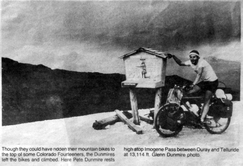
Aspen Times, December 26th, 1985
Travel to, and ascend ALL Colorado's 50-somethin' Ranked and Named 14,000+ foot peaks by fair means: legally, self-powered, and self-supported.
Start the challenge on any date and time, and location you choose. The Challenge is finished once you travel back to your original starting point. Your time to complete the challenge will be recorded (realized or unfinished).
No entry fee, no support, no registration, and no prize money. This challenge is run as self-timed Individual Time Trial. All that is provided here is a framework for your own adventure.
This challenge is open to anyone.
(back of the envelope)
This challenge will take much longer than other, similar 14er peak-bagging challenges that have a support crew and transportation to trails, as the Challenger will be burdened with the additional task of traveling to and from each summit, carrying all gear needed, sourcing food, supplies, etc. Some peaks may well require multiple attempts at summiting.
No one likes to be limited in what they do by rules of another. The below rules are set up to make this challenge a level playing field (as much as possible) for everyone, as well as sustainable for future challengers to engage in. They also try to define what the challenge actually is, and set guidelines on how to go about it. The bottom line is:
and,
The basic goal is to summit all the named and ranked 14ers.
This challenge has many free-form elements: where to start; route; self-powered transportation choices; summit order - and few prior challengers, in the same spirit. It's highly encouraged that any Challenger express their own unique style on the Challenge itself, regardless of the two main (perceived?) goals: Total time to complete the challenge, and successfully summitting of all name/ranked 14ers.
Style is wholly subjective and will in no way impact your final time - style points don't count that way, but that's not the goal of style. Style is leaving your own creative signature to the Challenge.
Some things to consider:
These types of style questions are left up to the Challenger.
Aspen Times, December 26th, 1985
Finding examples of people traveled to the trailhead by bike, in a self-supported-like mode are scarce. Some articles:
This Challenge is modeled after previous challenges, including:
Below is a rough draft of a planned route to cycle to and from the Trailheads that serve the Colorado 14ers - routes from the TH's to the summits are covered in detail in other resources.
Goals of this route are to provide an offroad route for travel as much as possible, using known routes like the Colorado Trail and the Great Divide Mountain Bike Route, as well as well-known Passes like Cinnamon, Imogene, Pearl, Taylor and Argentine. The object of this route is not specifically one of speed, but of adventure, as well as removing the Challenger from as many busy, paved routes as possible (although, sometimes even that is unavoidable). An entirely different route could be created if one wanted to optimize speed, and give up safety.
Starting at the Museum of Mountaineering in Golden, CO this route meanders through the last bastions of suburban sprawl of the greater Denver/Golden Frontrange Urban Corridor, towards the Northernmost terminus of the Colorado Trail, which itself can be taken all the way to Durango, CO (we'll revisit it, later on - a few times).
It's just a warm-up though, and our route leaves the CT on the dirt North Platte River Road. With a little jockeying to the East, you'll then meet up to the start of Rampart Range Road (dirt), which will take you all the way to Woodland Park and HWY 24, and a high-speed descent to the Barr TH in Mantiou Springs.
From here, it's the almost marathon-length route to Pikes Peak, and the first 14er of the trip. After 100 miles in the saddle on mostly dirty/trail, it's worthy of your time.
This is a fairly unscouted route (for me, personally) and unimaginative, to say the least. It does drop you off to some of the most interesting 14ers of the route, which is more than a righeous consolation:
As well as one of the four great 14er traverses: Crestone Needle -> Peak
After Pikes, this should be a stout wakeup call to the challenges that lay ahead.
After a short resupply in Westcliff, it's back to the grind, on another unimaginative route (with, perhaps a nice pass to liven things up) to take on another epic group of mountains:
As well as the second of the four great 14er Traverses: Little Bear -> Blanca
The last of the Sangres de Cristos, and the first full mountain range finished ends with a strange whimper, with the gentle slopes of pricey Culebra. Consider it a few days rest before the San Juans kick up.
Whisking quickly across the San Luis Valley, one will reach the foothills of the San Juans close to the New Mexican border, outside of Conejos, CO. From there, one will meet up with the Great Divide Mountain Bike Route, esqueing paved roads, and instead trading them for wide-open gravel grinding and a stout climb to wake you back up. We'll divert off the GDMBR near Indiana Pass, and take a more direct route towards our next objective, sadly missing Del Norte. With only the small hamlet of Platoro (don't drink the water) to hit before Creede, it should get your warmed up for the loneliness of the San Juans ahead. Creede will bring you to your first 14er, the gentle San Luis Peak.
An entire trip in of itself, the tour of the San Juan Mountains will have one travel in a counter-clockwise direction, ticking off the San Juan 14ers as they come, while you travel through this intense region via mountain pass upon mountain pass:
After San Luis, there's a resupply in Lake City, it's then off to top Cinnamon Pass, to summit Redcloud/Sunshine and Handies via Silver Creek/Grizzly Gulch TH.
Another resupply in Silverton will get you ready for the Chicago Basin 14ers, further South (Sunlight, Eolus, North Eolus, Windom)
The Wilson Group becons next (Wilson Peak, Mt. Wilson, El Diente) and the third great 14er traverse encountered - El Diente -> Mt. Wilson.
A resupply in Telluride will set one up for Imogene Pass and the 14er it allows access to: Mt. Sneffels.
A quick stop in Ouray, up Engineer Pass to tag Uncompahgre and Wetterhorn. Aren't you glad Lake City has that weird pizza parlor?
A somewhat devious route, as the highway N out of Lake City provides much easier passage, this route takes the stout hill out of Lake City and onto the Colorado Trail wilderness detour to Gunnison.
Once in Gunnison, things get easier until Crested Butte, where one will engage in historical-to-MTBers Pearl Pass, to reach Castle/Conundrum and Cathedral, a quick trip to Aspen (if they let you in the city limits, smelling like you do), and to the rest of the Elks: Pyramid, Maroon/North Maroon (completing the great 14er traverses) and then off to Capital and Snowmass. Once the Elks are surmounted, it could feel like the light at the end of the tunnel will finally be faintly visible in the distance.
Hangerman Pass is the missing link between the Elks and the Sawatch, and affords you to miss paved Independence Pass.
The Colorado Trail will be met again, this time for a more full engagement, The Sawatch have a bad rep. as talus slopes, but become delightful, when they're talus slopes linked together with sweet, smooth singletrack! Mt. of the Holy Cross is the odd-mountain out of the group, and should probably be tackled first to get out of the way. Then, enjoy the tour south, picking off 14ers on your way: Massive, Elbert, La Plata, Huron, Missouri, Belford, Oxford, Harvard, Columbia, Yale, Princeton, Antero, Tabeguache and Shavano.
Utilize Leadville, Twin Lakes, Salida, and Buena Vista as useful resupply points as you see fit. Figure out the best way to link up multiple Sawatch 14ers in a day, or you could be here for weeks.
After a few burritos, it's out the back door and onto the GDMBR, for a mellow dirt route back North to Hartsel , then Alma. Tag Sheridan, then Democrat, Lincoln, Cameron, Bross, and finally, Quandary to finish up the Mosquito/Tenmile range.
Take the side roads out of Breckenridge and Summit County and up 13,000+ Argentine Pass and back down to the I-70 corridor, a little bit of a backtrack to tag Grays/Torreys, then back up Guanella Pass to hit up Evans/Bierstadt. Back down Guanella Pass to Idaho Springs and time to realize you've only got one peak left: Longs Peak.
The route from Idaho Springs to the Longs Peak TH could be a highway slog, but this route tries to take smaller paved roads that end up as dirt tracks of varying quality. One could further string a single track route in the Nederland area, and perhaps beyond. The pull of private land, Wilderness and finally a National Park will force you back onto the highway, but not until you get tantalizingly close to the Longs Peak TH. Summit Longs Peak with righteous aplomb and savour the (now) relatively easy cruise back to Golden, CO, any way you see fit as you chase the coming change in seasons.